Loading...
Nairobi, Kenya
Mon - Fri : 08.00 AM - 06.00 PM
+254 758 832 883
Our Project Portfolio

Explore Our Latest Geomatics & Geospatial Projects

Our diverse portfolio showcases successful implementations across various industries, demonstrating our expertise in delivering high-quality geospatial solutions that address complex challenges.

  • All
  • GIS Mapping
  • Remote Sensing
  • 3D Modeling
Urban Planning GIS

GIS Mapping


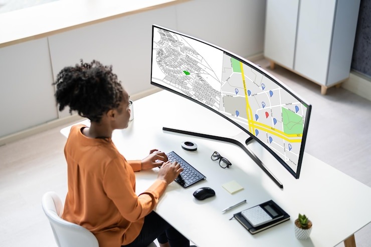
Urban Planning GIS for Vancouver Metropolitan Area

Comprehensive GIS development for urban planning, zoning analysis, and infrastructure management, enabling data-driven decision making for city development.

Forest Cover Change Detection

Remote Sensing


Forest Cover Change Detection Using Multi-temporal Satellite Imagery

Advanced satellite imagery analysis to monitor forest health and track deforestation patterns over a five-year period for environmental protection agencies.

Digital Twin Project

3D Modeling


Downtown Core Digital Twin Project with LiDAR Integration

Creation of a high-fidelity 3D digital twin of a major downtown area using LiDAR and photogrammetry for urban planning and emergency response simulation.

Utility Network Management

GIS Mapping


Utility Network Management System for Regional Water Authority

Comprehensive GIS implementation for water utility infrastructure management, including asset tracking, maintenance scheduling, and emergency response planning.

Agricultural Crop Monitoring

Remote Sensing


Agricultural Crop Monitoring System Using Multispectral Imagery

Custom remote sensing solution utilizing multispectral imagery for crop health assessment, irrigation optimization, and yield prediction for large-scale farming operations.

Infrastructure Corridor Planning

3D Modeling


Infrastructure Corridor Planning with Advanced Terrain Analysis

Detailed 3D terrain modeling and analysis for transportation corridor planning, optimizing route selection and minimizing environmental impact.

Our Project Approach

How We Deliver Successful Geospatial Projects

1. Discovery & Requirements

We begin each project with a thorough discovery phase to understand your specific challenges, objectives, and technical requirements. This foundation ensures our solutions align perfectly with your needs.

2. Analysis & Planning

Our geospatial experts analyze available data, identify gaps, and develop a comprehensive project plan with clear deliverables, timelines, and quality metrics to guide implementation.

3. Implementation & Testing

We execute the project using industry best practices and rigorous quality control processes, with regular client check-ins to ensure transparency and alignment throughout development.

Project Consultation

Discuss Your Geospatial Project

Have a geospatial challenge that needs solving? Our team of experts is ready to help. Fill out the form below to schedule a consultation where we can discuss your project requirements and how our geomatics services can meet your specific needs.

Testimonials

What Our Clients Say!